
Welcome to the CalmandStrong Kingdom
- calmandstrong

- Mar 11
- 21 min read
Updated: 4 days ago

If God gave you the supernatural ability to create your own country on Earth, what would be the name? What would it look like? Where would it be located? Choose up to six or less countries from any era of mankind (i.e., ancient, medieval, or the modern era) that could be combined and blended all in one.
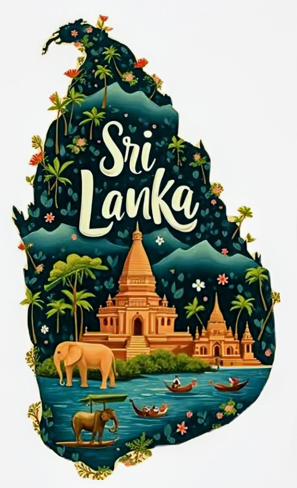
Image I (Top Left): Sri Lanka: Paradise Island in South Asia
Image II (Top Right): The Great Benin Empire: (Present-day Southern Nigeria)
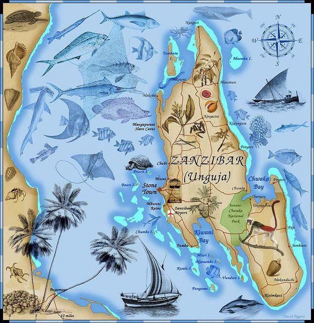
Image III (Middle Left): Zanzibar: Paradise Island off the coast of Tanzania (East Africa)
Image IV (Middle Right): Cape Verde: Paradise Island off the coast of West Africa
Image V (Bottom Left): The Minoan Civilization: (Present-day Paradise Island of Crete, Southeastern Europe)
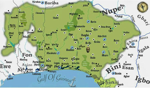
Image VI (Bottom Right): Yorubaland: (Present-day Southwestern Nigeria, a small part of Benin Republic and still a smaller part of Togo Republic (West Africa)
My six countries would be Yorubaland, The Great Benin Empire, Zanzibar Island, Sri Lanka Island, The Minion Civilization (i.e., Crete Island), and Cape Verde Island all combined and blended into a beautiful aqua tropical and lush rain forest setting off the coast of West Africa.
The History & Beautiful Landscapes of the CalmandStrong Kingdom
Sri Lanka (South Asia): Sri Lanka is a captivating island nestled in the Indian Ocean and has a rich history that dates back thousands of years. Sri Lanka is known as “The Pearl of the Indian Ocean,” and has been a land of legends.
The origins of Sri Lanka are deeply rooted in ancient times. Buddhism is one of the most influential religions in Sri Lanka, which arrived in the island during the reign of Emperor Ashoka during the 3rd century BCE. He was a powerful Indian ruler who sent his son Mahinda to introduce Buddhism to Sri Lanka. When Buddhism became a dominant religion in Sri Lanka, it shaped the island’s spiritual and cultural landscape. The island also has a wide range of habitats, including tropical rainforests, dry scrublands, wetlands, highland forests, and coastal ecosystems.
Amidst the dense jungles of Sri Lanka stands the architectural marvel that has captivated the world for centuries, Sigiriya, the majestic rock fortress of King Kasyapa. The fortress is built on a massive column of rock, reaching a height of over 200 meters (660 feet). The rock itself is a geological marvel, composed of hardened magma from an extinct volcano. Its sheer vertical walls, adorned with intricate frescoes, lead visitors to marvel at the ingenuity and engineering skills of the ancient Sri Lankans.
Sri Lanka is known for its remarkable biodiversity and rich wildlife, making it a true wonderland. Sri Lanka is referred to as the “Jewel Box of the Indian Ocean,” because it has a long and storied history of gemstone mining and trading. Due to Sri Lanka having natural gem deposits, the island has been a destination for gem enthusiasts and traders for centuries. Sri Lanka is blessed with an abundance of gemstones and vibrant rubies.
The Great Benin Empire (Present-day Southern Nigeria, West Africa): Great Benin was one of the greatest civilizations that Africa has ever produced, and this nation was founded by the Edo people in the tropical forests of West Africa. The capital of the empire was Benin City, and the Portuguese sailors of the 15th century who visited Benin City were amazed as they walked through streets laid out with mathematical precision, wide and straight, flanked by houses with upper stories, clay gables, and carved steps. At night, the streets glowed with the warm flicker of palm oil flames raised in clay pots. This system of street lighting was long before the gas lamps in Europe appeared on the scene. The Great Benin Palace was also immense because it sprawled across a landscape like a small town, filled with courtyards, chambers, and halls where every wall was alive with beautiful bronze and ivory sculptures, which told the story of the Edo people.
“Great Benin, where the king resides, is larger than Lisbon." - Portuguese Captain Lorenzo Pinto
Captain Pinto also described the streets stretching as far as the eye could see, palaces that seemed endless, and earthworks so massive that they rivaled the “Great Wall of China.” When Great Benin became a dominate power in West Africa, the empire seized, controlled, and taxed trade routes. The Oba (i.e., the King of Great Benin) appointed officials to rule over client states, which carried Great Benin’s court authority across miles of the forest and delta. The reach of Great Benin extended beyond present-day Southern Nigeria, because its reach went as far west as present-day Ghana and eastward toward present-day Cameroon.
The Edo people of Great Benin were known to take advantage of their country’s many natural rivers and creeks of the Niger Delta. War canoes were made from trees, and they were long and sleek, and carried warriors swiftly across the waters. Great Benin was a land where rivers were waterways, and Great Benin’s naval forces ensured that its reach extended beyond the dense forest, binding coastal towns into its network of tribute and allegiance.
It was this combination of land and water that made Great Benin one of the most powerful nations on the shores of West Africa during medieval times. Under the rule of King Ewuare the Great, Great Benin had transformed from a once modest kingdom with promise to a powerful empire that didn’t ask, but demanded respect and recognition, and the Edo peoples influence was felt across rivers, forests, and coastlines of West Africa. The name “Ewuare the Great,” is a name that still echoes with awe in oral traditions of the Edo people, because he was remembered as both a reformer and conqueror, a visionary who shaped the destiny of his people with fire, iron, and brilliance. The power of Great Benin was not only in its powerful armies or its borders, but in the heart of its governance.
Zanzibar (East Africa): The island of Zanzibar is situated about 25 miles off the Tanzanian coast in East Africa, and this island had no shortage of sultans and spices, merchants and mosques, dhows and doorways of richly carved timber, which captured the imagination of travelers and writers for hundreds of years.
“It was then capital of an Afro-Arab dynasty, a centreof commerce and international diplomacy, a seat of learning…and a gateway of Africa.” – Abdul Sheriff, 1995
Ugunja Island, now known as present-day Zanzibar, is the largest of a number found in the Zanzibar archipelago, separated from the mainland by the narrow Zanzibar Channel. The other main islands are Pemba and Tumbatu. It was Ugunja that was the focus of most human activity in the archipelago, developing into the major trade and communications entrepôt of the Indian Ocean from the 17th century onward. Zanzibar has longed evoked a romantic mystique, calling up images of an island paradise in the warm waters of the Indian Ocean. For much of the last millennium, the island served as the center of maritime interaction and trade between Africa, the Arabian Peninsula, and India, and the architectural and urban heritage of Zanzibar reflects the complex fusion of these cultural influences.
The islands of the Zanzibar archipelago are ancient, because it was formed during the late Pleistocene epoch, about 12,000 years ago. They are mainly composed of limestone, the properties of which characterized the development of the coastal and landscape feature of Zanzibar over the millennia. Zanzibar can be divided into three zones, which are the coastal plain, the low-lying corridors, and the elevated areas. The coastal plain is characterized by coral reef limestone areas and shallow, sandy beaches. The corridor zone comprises wide-bottom valleys flanked by elevated areas of hills and ridges. There are no mountains in Zanzibar, and the elevated areas consist mainly of ridges, fault structures, and the upper corridor valleys. The urban landscape of Zanzibar contains several iconic structures and a wide variety of vernacular architectural styles. Stone Town, for example, has undergone both development and regression. The main buildings of the town can be viewed today that were built during the 18th and 19th centuries.
Houses on the island display elements of Omani Arab traditions regarding the domestic sphere, especially concerning the usage of open spaces. Much like the earlier Swahili style of residential building, instead of making spaces open and public, courtyards were enclosed on all sides by the house, masking them from view by those on the street. Most of the structures were long, narrow rooms leading into this open, central courtyard. The fronts of these massive homes were topped with pitched tile roofs and built on a square plan. The walls were punched with small windows that provided some light whilst maintaining the privacy of the household, and wide and open balconies circled the interior courtyard.
The History of the CalmandStrong Kingdom

Image I (Top Left): Was the Benin Kingdom Ever an Empire? Power, Intrigue, and the Untold Greatness of Precolonial Africa, by Collins JK. Smith
Image II (Top Middle): Zanzibar: The History of the International Trade Center off the Coast of Africa, by Charles River Editors
Image III (Top Right): A Brief History of Cabo Verde (A Brief History – Around the World Edition), by KJ Smith
Image IV (Bottom Left): The History of Sri Lanka: From Sigiriya to Serendipity, by Dilshan Jensen and Einar Felix Hansen
Image V (Bottom Middle): Minoan Civilization: A History from Beginning to End, by Hourly History
Image VI (Bottom Right); A History of the Yoruba People, by Dr. Stephen Adebanji Akintoye
Cape Verde (West Africa): Cabo Verde (Cape Verde) is an archipelago of 10 volcanic islands, and rests in the heart of the Atlantic Ocean, about 570 kilometers (354 miles) off the coast of West Africa. Cape Verde is volcanic in origin, has a tropical climate, and has its own distinct landscape, ranging from lush, mountainous terrains to arid, desert-like environments. The largest island is Santiago, which is the home of the capital city of Praia and serves as the country’s political and economic hub. Although Cape Verde is geographically distant from the mainland of Africa, its history is profoundly intertwined with the European Transatlantic slave trade, European colonization of Africa, and the global forces that shaped the modern world.
Cape Verde, like some of its beautiful island counterparts, like Sri Lanka (South Asia), Zanzibar (East Africa), and Crete (Southeastern Europe) has beautiful landscapes, which includes pristine beaches and rugged mountain ranges. This has made the country an attractive destination for many international tourists.
The island is a unique blend of African, Portuguese, and maritime influences, which makes Cape Verde and its people a testament to resilience and cultural fusion. Although the story of Cape Verde is one of discovery, displacement, survival, and eventual triumph, the islands were uninhabited when the Portuguese arrived during the 15th century, and they took advantage by wasting no time in colonizing Cape Verde. Before the arrival of the Portuguese, Cape Verde was likely known to African sailors and traders, because according to Dr. Chancellor Williams, author of The Destruction of Black Civilization: Great Issues of a Race from 4500 B.C. to 2000 A.D., he said:
“Many, like the early Blacks themselves, were seafaring men. That the Blacks were once among the most adventurous of peoples is evidenced not only by the presence of their descendants in many lands, (i.e., Asia, Europe, the Americas, Oceania, etc.) and numerous far flung islands, but also by archaeological remains found in various parts of Europe.”
Just because Black people chose not to permanently settle the beautiful island of Cape Verde before European conquest and colonization of Africa doesn’t mean that Black people were oblivious of the island’s existence.
Portuguese colonial rule in Cape Verde was like much of Africa during the European occupation of Africa, which was marked by exploitation and subjugation. However, the seeds of resistance spread throughout many Cape Verdeans, and they were inspired by the broader struggles for African independence, because the Cape Verdean people were yearning for self-determination and independence. The path to independence wouldn’t become realized until 1975, following the Carnation Revolution in Portugal. Cape Verde’s peaceful transition to independence was led by figures like Amílcar Cabral, which marked a new chapter in Cape Verde’s history.
The Minoan Civilization (Present-day island of Crete, Southeastern Europe): The Minoan Civilization reached its height during the Middle Bronze Age, from 2000 BCE until 1500 BCE. The Minoan are perhaps best known for their labyrinth-like palace complexes, and their vivid frescoes depicting both men and women leaping over bulls, with their fine jewelry, elegant stone vases, and pottery with vivid colored decorations of marine life. In his epic poem The Odyssey, Homer from ancient Greece described the center of Minoan Civilization as Crete, an island off the southern coast of Greece, and he said the island was:
“a rich and lovely sea-grit land, densely peopled, with 90 cities and several different languages.”
Crete is the fifth-largest island in the Mediterranean Sea, and is the largest of the present-day Greek isles, covering about 3,200 square miles. Crete lies to the south of the Aegean Sea and forms a link between Europe, Africa, and Asia, which can be seen in the archaeological remains uncovered on the island. The island is mountainous, a distinct characteristic of the landscape. There are three mountain ranges, each of which is seen having its own distinct personality. Between each of these ranges are semi-mountainous zones that cover a large part of Crete, and there are also some low-lying plains and several plateaus. Crete also has several natural harbors. One of the most well-known sites is Knossos, which is also the largest archaeological site in Crete.
At its peak in the 17th century BCE, Crete had a population of 20,000 and 100,000 people. With this large estimate, Knossos was an important cultural center in the Minoan Civilization. The great palace and palatial complex at Knossos were built on top of Kefala Hill over time between about 1700 and 1400 BCE, and it shows evidence of numerous construction phases, many of which followed some kind of destructive event.
“We know now that the old traditions were true. We have before our eyes a wondrous spectacle ̶ the resurgence, namely, of a civilization twice as old as that of Hellas. It is true that on the old Palace site what we see are only the ruins of ruins, but the whole is still inspired with Minos’s spirit of order and organization.” – Sir Arthur Evans
The location of Crete gave the Minoan “Sea Kings” command of the seas, and that facilitated the spread of Minoan culture throughout the region. Myths tell of the founding of Crete by King Minos, the son of the God Zeus and the Phoenician Princess Europa. Historian Thucydides described Minos as a conqueror who expanded Cretan territory to include the Cyclades, a group of more than 30 islands scattered throughout the Aegean Sea north of Crete. It was said that King Minos was advised by Zues, and under his rule, that Crete build a formidable navy which defeated the rival city of Athens. According to legend, King Minos reported to have demanded that Athens send 14 young men to be sacrificed to the Minotaur, a half-man, half-bull who lived in the labyrinth on the island.
King Minos installed his sons on the throne, and together they sought to rid the islands of pirates. Their efforts paid off because the Minoan Civilization lived a relatively peaceful existence until its collapse following a violent volcanic eruption on what is now the island of Santorini, then known as Thera.
Modern historians believe the Minoans weren't aggressive with their navy, mainly using it to dominate trade rather than conquer perceived enemies. This theory is supported by archaeological evidence, which has revealed that the Minoan Civilization did have an extensive trade network. Remnants of Minoan architecture, pottery, and frescos have been found on many islands on the Aegean Sea, and goods have been discovered in Cyprus, Syria, Egypt, and Mesopotamia.
Yorubaland (Present-day Southwestern Nigeria, a small part of Benin Republic and still a smaller part of Togo Republic (West Africa): Yorubaland and the Yoruba people are neighbors to the Edo people and Great Benin in present-day Nigeria (i.e., Great Benin is located southeast of Yorubaland), and these two West African nations are intertwined together through history, culture, governance, etc. For instance, according to Edo traditions, Great Benin was ruled by ancient rulers known as Ogiso, and the country fell into disorder under their rule. Some Edo leaders sent a message to the ruler of the Yoruba Ife Kingdom, and the ruler was called the “Olofin” or “Ooni,” urging him to send help for reorganization of the country. The king of Ife, according to Edo traditions claim it was Oduduwa, the divine king of the Yoruba people. The king of Ife responded by sending Oranmiyan, one of King Oduduwa’s youngest grandsons and the foremost warrior prince that the Ife Kingdom produced.
Did You Know? The Yorubaland & Great Benin Connection

The Yoruba God-King
Ooni (i.e., King) Oduduwa of the Ife Kingdom: The “Mighty Lord of Ife”
“Of the human actors in this revolution, the greatest, according to all the traditions, was Oduduwa. So monumental was the role of this man that, probably even from as early as his own life-time, popular traditions and legends elevated him to the awesome pedestal of father of the Yoruba race and founder of the monarchical system which thenceforth became their typical system of government. His successors deified him, and subsequent generations transposed him all the way back to the very beginning of creation and crowned him as the first human to walk the earth, the progenitor of the Yoruba race.”
– Dr. Stephen Adebanji Akintoye
The leaders of Ife left a distinctive lasting impression with their “Calm and Strong” personalities.
The Ife Kingdom came into existence during the 9th century, but Ife became a powerful empire from the 10th-14th centuries. Ibn Battuta, the 14th century Moroccan scholar was informed during his visit to the Golden Mali Empire (February 1352 to December 1353) about a powerful kingdom called Yufi (the Ife Empire), which his informants described as:
“one of the biggest countries of the Sudan, and their sultan one of their [sic] greatest sultans.”
The Ife Kingdom eventually became an empire, without violence and the use of force of arms. The “Ife Empire” was held together by power of commerce, the belief in a common ancestry, and the manifested oneness of cultural heritage. Ife was universally regarded as a Yoruba community of practice as the ultimate place of origin, located between heaven and Earth. It was believed across the Yoruba-Edo world that the souls of the deceased returned to Ife, where they reincarnated in preparation for a new life. This universe created by the Yoruba (Ife) people revolved around the Ife Empire as its point of reference, and the (Edo) Great Benin Kingdom and the (Yoruba) Oyo Kingdom were its two anchors.
When other Yoruba kingdoms began to emerge, each of them acknowledged Ife as the head, and looked up to Ife as source of life and light rather than a rival. During the 15th century, Ife began to decline as power rivals such as the Great Benin (Edo) and Oyo (Yoruba) kingdoms emerged as economically, politically, and militarily stronger than Ife. By the end of the 18th century, Ife was a small and weak kingdom in the heart of Yorubaland, but all other Yoruba kingdoms continued to regard it with awe.
By the 19th century, the Ife Kingdom was destroyed in war and lay in ruins, and the oracles warned gravely from all corners of Yorubaland that the Yoruba country would never know peace until Ife had been resettled and accorded respect and honor due to it. When the Ife Chiefs and their people were camped at the Isoya village, just outside the ruins of their kingdom. The chiefs stated the Ife people were “the fathers of all tribes,” and if the Ife’s continued to camp and were not able to resettle their kingdom, “the whole world would spoil, as they were the priests of the deities (i.e., Yoruba deities called Orishas) who ruled the world.”
Amongst the Yoruba people, it was known throughout Yorubaland that the Ife Kingdom must not be violated, because to assault the Ife Kingdom was to upset the supernatural guarantees that sustained the world.
“The idea of a living god in human form sitting atop the political organization of the ìlú (i.e., a city-state, kingdom, town, or urban space) was a profound shift in Yorùbá political ideology.” – Dr. Akinwumi Ogundiran
The Yoruba king was a sacred God-King. His rulership was shrouded in religious mystery, rituals, observances and sacrifices. Both his personality and office were divine. In other words, the human body of the Yoruba king was more than the vessel in which the Orishas and the ancestors were manifested. In fact, the Yoruba king was an Orisha, a God or divine being in his own right. During the Classical period of Ife (1000-1420 AD), Yoruba kings did not have to wait till death to become ancestors and deities, because they were living gods who could not die. The Yoruba king did not have to wait to be deified after his death, since he was already chosen and anointed as the “Lieutenant of God on Earth.”
“The royal city of Ile-Ife, the heart of the kingdom of Ife – and source of light to the Yoruba people – had come to stay.” - Dr. Stephen Adebanji Akintoye
When Prince Oranmiyan was sent to Great Benin by his grandfather, King Oduduwa, to help bring peace and order to the Edo country, he was welcomed by some Edo leaders but was resisted by others. He suppressed the resistance and established order and a strong monarchy known as the “Oba Dynasty.” After spending some years in Great Benin, Prince Oranmiyan decided to leave, because he felt an indigenous Edo prince should rule over Great Benin. So, he installed his son from one of his Edo wives to the Great Benin throne, and his name was Eweka. Eweka, the king and “son of the soil” who represented the Yoruba-Edo world. This young Yoruba-Edo king became the progenitor of the Oba Dynasty and made Great Benin one of the most power nations on the shores of West Africa. Like the Yoruba “God-King,” the Edo king of Great Benin was also a divine figure or a “God-King” who was believed to bridge the realm of men and the gods.
It is well known that Great Benin is a related state of Yorubaland, specifically the Ife Kingdom. The Oyo Empire (which was founded by Oranmiyan after he left Great Benin. He also established another dynasty, the “Alaafin Dynasty” of Oyo) of Yorubaland and Great Benin have been listed as some of the most outstanding nations to represent African development up to the eve of the European arrival during the 14th century.
The Yoruba has a very large population, estimated between 30 and 40 million people, and they may perhaps be the largest single ethnic group, or nationality in Africa. The Yoruba people are ancient, because according to all evidence from archaeological and allied research, the Yoruba, as one distinct group have been living in their present-day homeland in West Africa since as far back as 8,000 years ago. Since then, the Yoruba people have owned and held their homeland and developed it from age to age the highest level of civilization in tropical Africa below the Sahara. They are also the most urbanized people in the history of the African forest lands, having lived in walled cities and towns since as early as the 11th or 12th century. These towns and cities evolved a sophisticated monarchical system of government, whose governing elites established detailed institutions and processes for preserving society’s history and passing it on. When it comes to education, the Yoruba people has established a reputation of being “Academic Giants,” because by the end of the 20th century, the Yoruba were widely regarded as the most literate people in Africa.
Yorubaland is presented with two distinct features, which are the forest and the plain. For example, Eastern and Southern Yorubaland are forested regions, while Northern, Central, and Western Yorubaland are plain and forest regions. The nation is well watered, but rivers and streams are dependent upon annual rain; an impassable river in the rain may become but a dry water course in the dry season. Some of the biggest rivers in Yorubaland flowed through the very thicky Yoruba Ondo Kingdom. In the eastern part of the kingdom, the Orosun Hill (including the Idanre Rock) rises abruptly, forming the highest peak in Yorubaland at 3098 feet above sea level.
There are a few mountains in the north and west, but in the east the prevailing aspect is high ranges of mountains from that part of the country. This is where the Ekiti Yoruba Kingdom dwells, because its name “Ekiti” means a mound; being covered as it were with Nature’s Mound. The soil of Yorubaland is particularly rich, and most suited for agriculture, and minerals are plenty, since the forests teem with economic and medical plants of tropical varieties as well as timber.
Yorubaland before the European colonial era was a very prosperous and powerful country, and some Yoruba states, like Ibadan, Abeokuta, and Ajaye had populations of up to 100,000 citizens or more, which was as large as most city-states of feudal Germany.
“the Yorubas deserve particular notice … they are a fine race … their houses neat, comfortable and kept in perfect order within. In character, they are generally honest, and in disposition proud, and even haughty.” – Dr. de Verteuil
Where Would this Amazing Nation: The CalmandStrong Kingdom be Located?


Image I (Left): Paradise Island of Crete

About 25 miles apart
Image II (Right): Paradise Island of Cape Verde
The Beautiful Island of Crete
“a rich and lovely sea-grit land, densely peopled, with 90 cities and several different languages.”
- Ancient Greek Poet Homer
The Beautiful Island of Cape Verde
Cabo Verde (Cape Verde) is an archipelago of 10 volcanic islands, and rests in the heart of the Atlantic Ocean, about 570 kilometers (354 miles) off the coast of West Africa. The island has beautiful landscapes, including pristine beaches and rugged mountain ranges.

About 12 and a half miles from Zanzibar-Sri Lanka Island is Cape Verde Island to the right, and Crete Island to the left


Top: Paradise island of Sri Lanka
Zanzibar and Sri Lanka combined: Zanzibar-Sri Lanka Island
Bottom: Paradise island of Zanzibar
The Beautiful Island of Sri Lanka
The Beautiful Island of Zanzibar

About 25 miles off the coast of the Eko Kingdom (present-day Lagos, Southwest Nigeria, formally the Southwestern coast of Yorubaland) is Zanzibar-Sri Lanka Island
The Royal West African Civilizations: Yorubaland & The Great Benin Empire


Images I (Left): Yorubaland
Image II (Right): The Great Benin Empire
The Eko Kingdom (i.e., Lagos) of Yorubaland
The Yoruba people are ancient, because according to all evidence from archaeological and allied research, the Yoruba, as one distinct group have been living in their present-day homeland in West Africa since as far back as 8,000 years ago.
Benin City, Capital of The Great Benin Empire
During medieval West Africa, Portuguese Captain Lorenzo Pinto described the streets of Benin City stretching as far as the eye could see, palaces that seemed endless, and earthworks so massive that they rivaled the “Great Wall of China.”
The Untold Greatness of Precolonial West Africa: Yorubaland & The Great Benin Empire

King Obalufon I of the Ife Kingdom (Yorubaland)

Edo artist/Benin kingdom court style, plaque, mid-16th to 17th century, copper alloy; collection of Smithsonian National Museum of African Art (images courtesy the Smithsonian NMAfA)
My country, the "CalmandStrong Kingdom" would be in West Africa; the same region where Yorubaland and Great Benin were during ancient and medieval times, which is the combined territories of present-day Southwest Nigeria, and parts of present-day Benin Republic and Togo Republic (i.e., Yorubaland), and The Great Benin Empire (i.e., Southern Nigeria).
The Yoruba Eko Kingdom (present-day Lagos) is in the Southwestern coast of Yorubaland, which consist of a group of small islands and the low-lying forests in its immediate hinterland. About 37 miles from Lagos, there will be four more paradise islands in the Atlantic. The first 25 miles off the coast of Yorubaland will be two islands: Zanzibar and Sri Lanka combined. After about 12 and a half miles from Zanzibar-Sri Lanka Island, Cape Verde will be diagonally to the right, and Crete will be diagonally to the left, and both Cape Verde and Crete will also be parallel, about 25 miles apart.
Sources:
Akintoye, B. The Good News: Paths to Prosperity in Our Orilede Yoruba. TAC PUBLISHERS. (May 22, 2023). March 7, 2026. p. 9.
Akintoye, S. A History of the Yoruba People. Amalion Publishing. (Jan 1, 2010). March 7, 2026. p. Cover, 8-9, 17, 86-87, 104, 128-129, 145, 151, 145, 156, 171, 186, 191, 202, 223, 245, 581, 620.
Aina, T. Is this the MOST BEAUTIFUL place in LAGOS Nigeria? Tayo Aina. YouTube. Aug. 21, 2017. March 11, 2026. https://www.youtube.com/watch?v=L6v1abDaktQ&list=PLYuLRwFljIqYKEp4q50ar8IQH4ltCANAW&index=1
Charles River Editors. Zanzibar: The History of the International Trade Center off the Coast of Africa. Charles River Editors. (Oct. 14, 2016). March 7, 2026. Location: 17, 24, 40, 64, 72. p. Cover, 7.
Daily Afrika. Brief History of Oduduwa. Medium. June 19, 2020. March 7, 2026. https://medium.com/@abebaebrima/brief-history-of-oduduwa-ccfefafd3495
Earth Relaxation. FLYING OVER SRI LANKA (4K UHD) - Peaceful Music With Wonderful Natural Landscape For Relaxation. Earth Relaxation. YouTube. Aug. 6, 2022. March 11, 2026. https://www.youtube.com/watch?v=gwTBhzvaWWU&list=PLYuLRwFljIqYKEp4q50ar8IQH4ltCANAW&index=5
Eboh Media. This is Benin City, Nigeria. Eboh Media. YouTube. July 1, 2020. March 11, 2026. https://www.youtube.com/watch?v=_MXWVguVmGA&list=PLYuLRwFljIqYKEp4q50ar8IQH4ltCANAW&index=2
Genius. Brymo. Dem Dey Go. Klĭtôrĭs. Genius. 2016. March 12, 2026. https://genius.com/Brymo-dem-dey-go-lyrics
Genius. Rema. BENIN BOYS. HEIS. Genius. June 21, 2024. March 12, 2026. https://genius.com/Rema-and-shallipopi-benin-boys-lyrics
Hand Luggage Only. 14 Best Things To Do in Crete, Greece. Hand Luggage Only. May 29, 2025. March 7, 2026. https://handluggageonly.co.uk/14-amazing-things-crete-greece/
Hansen, E., Jensen, D. The History of Sri Lanka: From Sigiriya to Serendipity. Dilshan Jenson. Einar Felix Hansen. June 3, 2023. March 7, 2026. p. Cover, 7, 14, 67, 83.
Hourly History. Minoan Civilization: A History From Beginning to End (Ancient Civilizations). Hourly History. (October 17, 2021). March 7, 2026. p. Cover, 3, 5-6, 12-13.
Johnson, S. The History of the Yorubas From the Earliest Times to the Beginning of the British Protectorate. Forgotten Books. (July 3, 2012). March 7, 2026. Location: 350, 359, 377.
Laza, S. Hidden Gems in Crete, Greece. Sam Laza. Pinterest. March 7, 2026. https://www.pinterest.com/pin/690739661645260012/
Madushika, A. Sri Lanka Map. Ayesha madushika. Pinterest. March 7, 2026. https://www.pinterest.com/pin/690739661645260000/
MediaMOF. File:Ososo hills and mountain 1001 15.jpg. Wikimedia Commons. July 23, 2023. March 7, 2026. https://commons.wikimedia.org/wiki/File:Ososo_hills_and_mountain_1001_15.jpg
MK Store. Map County Cape Verde. MK Store. Displate. March 7, 2026. https://displate.com/displate/1787103?art=5c9704dd64bf4&utm_source=Pinterest&utm_medium=organic
Ndongala, L. Cape Verde Travel Bucket List. Leonella Ndongala. Pinterest. March 7, 2026. https://www.pinterest.com/pin/690739661645259998/
Ogundiran, A. The Yoruba: A New History. Indiana University Press. Nov. 3, 2020. March 7, 2026. p. 7, 55, 70, 95-96, 105.
Oramfe. File: Yorubaland Cultural Area of West Africa.jpg. Wikimedia Commons. Jan. 4, 2016. March 7, 2026. https://commons.wikimedia.org/wiki/File:Yorubaland_Cultural_Area_of_West_Africa.jpg
Packard, C. Smithsonian Takes Benin Bronzes Off Display, Considers Reparation. Hyperallergic. Nov. 10, 2021. March 10, 2026. https://hyperallergic.com/690913/smithsonian-takes-benin-bronzes-off-display-considers-repatriation/
PayHip. The Ultimate Sri Lanka Adventure : From beaches to Jungles & Ancient Temples. PayHip. March 7, 2026. https://payhip.com/b/1hUIC?utm_source=Pinterest&utm_medium=organic
Polychronis Film. [4K] CRETE 2026 4 HOUR Drone Aerial of Agios Nikolaos Elounda & Spinalonga | Greece Kreta Creta. Polychronis Film. YouTube. March 25, 2024. April 3, 2026. https://www.youtube.com/watch?v=G0P_7RTqreQ
Power House. Lagos, Nigeria image. Power House. Pinterest. March 7, 2026. https://www.pinterest.com/pin/690739661645259962/
Pressreader. A Kingdom Cast in Bronze. Press Reader. July 8, 2021. March 10, 2026. https://www.pressreader.com/uk/bbc-history-magazine/20210708/282342567816806
Relaxing Nature Music. Zanzibar in 4K ULTRA HD - Tropical Paradise in Africa | Scenic Relaxation Film With Calming Music. Relaxing nature Music. YouTube. Dec. 30, 2021. March 11, 2026. https://www.youtube.com/watch?v=DZnw2TeLuEU&list=PLYuLRwFljIqYKEp4q50ar8IQH4ltCANAW&index=4
Rodney, W. How Europe Underdeveloped Africa. Verso. (Nov. 27, 2018). March 7, 2026. p. 133, 138.
Safari Soles Tours. Zanzibar in 7 Days: The Ultimate Island Itinerary & Aesthetic Guide. Safari Soles Tours. Pinterest. March 7, 2026. https://www.pinterest.com/pin/690739661645259996/
Santos, C. Zanzibar map image. Carmen Vernetta se los Santos. Pinterest. March 7, 2026. https://www.pinterest.com/pin/690739661645260542/
Scenic Relaxation. Cape Verde 4K – Scenic Relaxation Film With Calming Music. Scenic Relaxation. YouTube. April 19, 2026. April 24, 2026. https://www.youtube.com/watch?si=XMkHcOOten6pSclx&v=e1USo9WZYnk&feature=youtu.be
Smith, C. Was the Benin Kingdom Ever an Empire? Power, Intrigue, and the Untold Greatness of Precolonial Africa. Collins JK. Smith. September 3, 2025. March 7, 2026. p. Cover, 1, 6-7, 40, 43, 47, 70.
Smith, K. A Brief History of Cabo Verde (A Brief History – Around the World Edition). KJ Smith. February 8, 2025. March 7, 2026. p. Cover, 1-5, 25, 49.
Williams, C. The Destruction of Black Civilization: Great Issues of a Race from 4500 B.C. to 2000 A.D. Third World Press; 3rd Revised ed. edition. (Feb. 1, 1992). March 7, 2026. p. 195, 250.


Comments